GEOGRAPHY, RECTANGLES 2,3 and 4
2.- THE EARTH The Axis is the imaginary line that goes from the North Pole to the South Pole. The Equator is the imaginary line that goes around the middle of the Earth. Northern Hemisphere is the northern half part of the Earth. Southern Hemisphere is the southern half part of the Earth. |
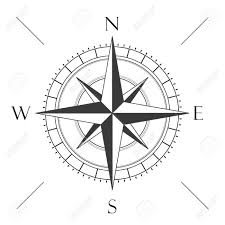
3.- THE CARDINAL POINTS There are four cardinal points: North (N), south (S), east (E) and west (W). There are also four intermediate points: North-east (NE), south-east (SE), north-west (NW) and south-west (SW). Remember that the east is where the sun rises every morning!! |
4.- STREET MAPS AND PLANS 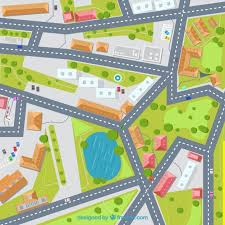 A street map is a small representation of a town or city. It shows streets, parks and the most important places using symbols . It’s divided into squares and uses a scale: 1cm=10m) A plan represents a room or a building. It also has a scale. 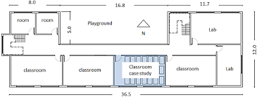 |
MAP SKILLS GAME
MAPS
RECTANGLE 1
1.- MAPS Maps can represent the World, a continent, a country or a region. Different maps show different information: A relief map shows high land in brown and low land in green,. Rivers are blue lines. A political map shows the border of a country and its different regions. There are a red dot and black dots. A road map uses different colours for different types of roads. |
GEOGRAPHY
Empezamos nuevo bloque temático: geografía.
En las siguientes semanas trabajaremos:
Planos y mapas.
1. Interpretar los signos convencionales que aparecen en un mapa.
2. Identificar y utilizr mapas de distintas escalas.
3. Dibujar planos sencillos con distintas escalas.
Mapa de Europa. Otros continentes.
4. Localizar en el mapa político de Europa los distintos países y conoce sus capitales.
5. Localizar en el mapa físico de Europa los mares, ríos y cordilleras más importantes.
6. Identificar algunos países, ciudades, ríos y cordilleras de países no europeos.
Mapa físico de España. El relieve y los principales ríos.
7. Localizar en un mapa de España las principales cordilleras y montañas.
8. Localizar en un mapa de España los ríos más importantes. Identifica su lugar de nacimiento y desembocadura, así como sus afluentes principales.
UNIT 8: I'D LIKE A MELON
VOCABULARY
PASTA
BREAD
CEREAL
MEAT
MELON
CUCUMBER
ONION
LEMON
CHILD
SHIELD
FIELD
BELT
QUILT
ADULT
POTATO
BUTTER
CHEESE
SALT
PEPPER
PEAS
GRAMMAR
I WOULD LIKE....... = I’D LIKE............
SOME
AN
A
UNITS 7 & 8 TEST ON TUESDAY 19th
DOG'S LIFE
 DRgMdswCYnkLcyt/learnenglishkids.britishcouncil.org
ANIMALS TEST
ANIMALS TEST
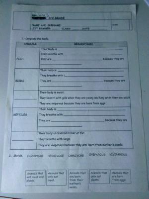
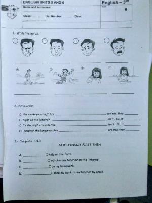
units 5&6 test
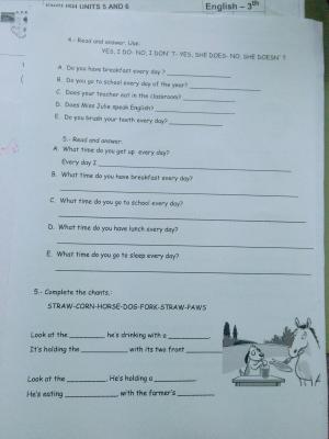
THIS IS OUR LAST TEST OF ENGLISH.
units 5&6 test
UNIT 7: PLACES TO GO
VOCABULARY
CAFE
LIBRARY
MUSEUM
PLAYGROUND
SHOPPING MALL
SPORT CENTRE
SWIMMING POOL
CINEMA
COW
CLOWN
FLOWERS
HOUSE
TROUSERS
MOUSE
PLAY
THEATRE
CONCERT
ACTOR
FILM
SINGER
GRAMMAR
ALWAYS
SOMETIMES
NEVER
IN
ON
AT
MIXTURES, ALIEN SOUP
